Weather Explained
Snow at 33°F: what three Montana airports reported
Matched airport reports from October 11–12 show snow near 33°F in Livingston and a later rain–snow mix in Billings. See what temperature alone cannot tell us.
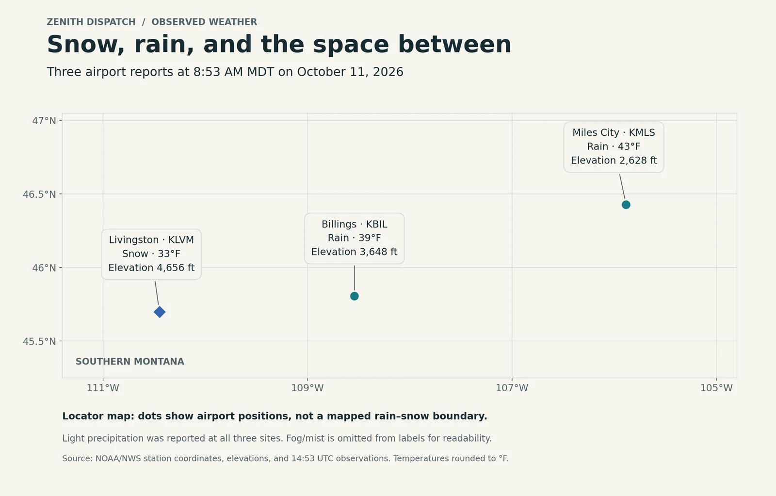
At 8:53 AM MDT on October 11, 2026, Livingston's airport reported light snow at about 33°F. Billings reported light rain at 39°F, and Miles City reported light rain at 43°F. Later that evening, Billings reported a rain–snow mix at about 33°F.
These airport reports offer a useful answer to a common question: can snow reach the ground when a thermometer reads above freezing? Yes. The temperature at one height is only part of the path a snowflake takes.
Three places, one matched moment
The comparison uses observations from Livingston Mission Field (KLVM), Billings Logan International Airport (KBIL), and Miles City's Frank Wiley Field (KMLS). All times below are local MDT. Temperatures are converted from Celsius and rounded to the nearest Fahrenheit degree.
At 8:53 AM on Sunday, October 11:
- Livingston: light snow, 33°F, station elevation about 4,656 feet.
- Billings: light rain, 39°F, station elevation about 3,648 feet.
- Miles City: light rain, 43°F, station elevation about 2,628 feet.
These are airport observations, not reports for every neighborhood in those cities. We have not substituted one site's conditions for another's.
Sources: the matching Livingston, Billings, and Miles City reports, plus NWS station metadata for KLVM, KBIL, and KMLS.
Billings changed as the evening cooled
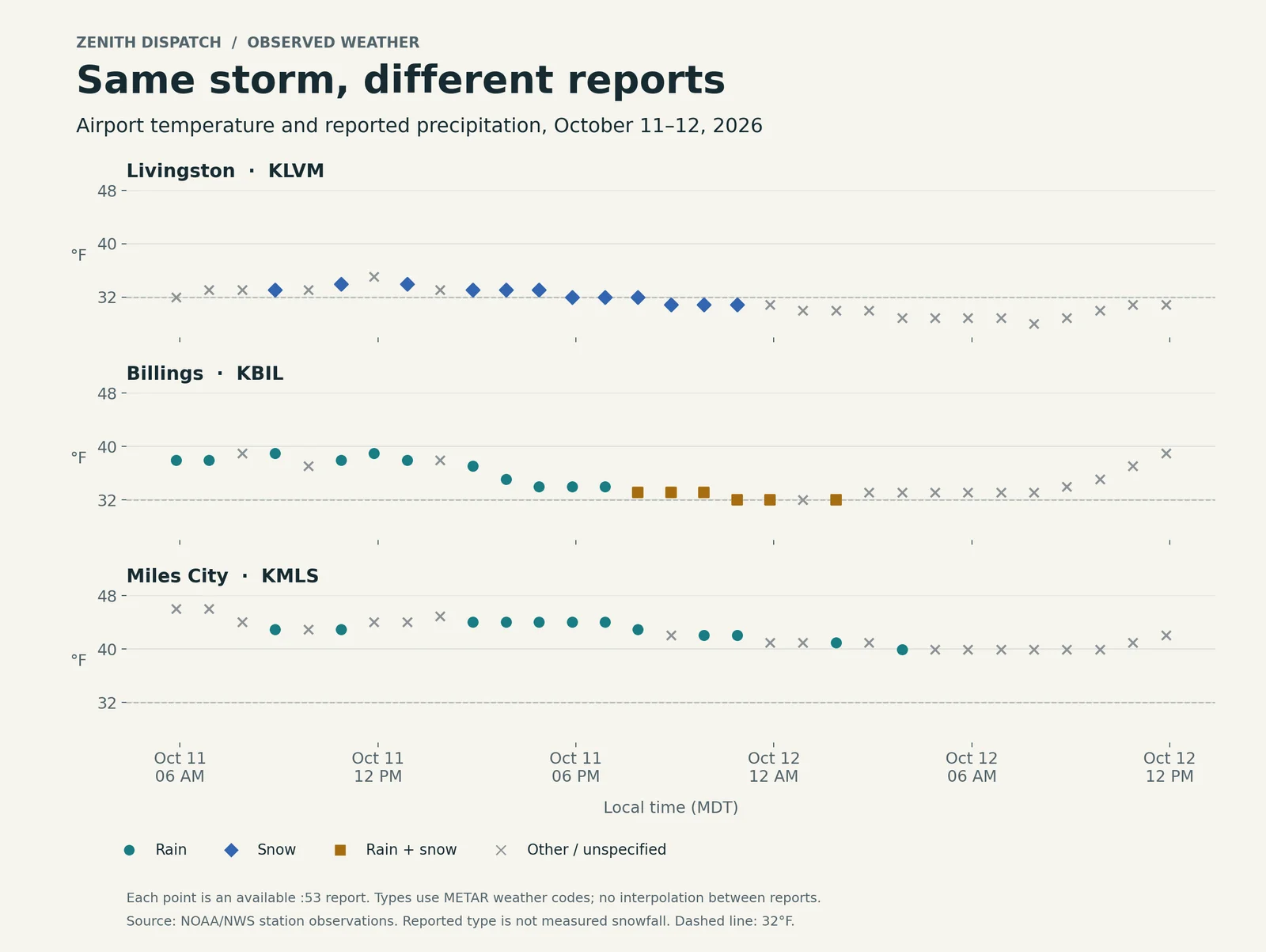
By the 7:53 PM report on October 11, Billings was reporting light rain and snow together at about 33°F. Its 10:53 PM report recorded the mix at 32°F. At that same 10:53 PM timestamp, Livingston reported light snow at about 31°F, while Miles City reported light rain at 42°F.
That evening comparison matters because it holds the observation time constant. Comparing Livingston's morning snow with Billings' warmer afternoon would mix a place difference with a time difference.
The Billings reports show a transition in what was reported at the airport. They do not establish the exact minute it began throughout the city, how much snow accumulated, or where a continuous rain–snow boundary lay.
Sources: Billings at 7:53 PM, then Billings, Livingston, and Miles City at 10:53 PM.
Why snow can survive above 32°F
A snowflake falling through air warmer than freezing begins to melt. Whether it melts completely depends on the warmth and depth of that layer, not just the temperature at the weather station. A shallow layer only slightly above freezing can allow snow to reach the ground before melting finishes.
That makes Livingston's snow report near 33°F physically plausible. It also explains why 32°F is not a universal switch between rain and snow at the surface. The NWS guide to temperature and precipitation type distinguishes surface temperature from the air above it.
Elevation is relevant, but these three stations do not isolate its effect. They sit in different places, with different terrain and air masses. Without vertical temperature profiles and a denser set of observations, we cannot assign a precise share of the difference to elevation, cooling from precipitation, or other processes.
How this compares with the forecast
The NWS Billings discussion issued at 5:53 AM MDT on October 11 separated western mountain snow, wet snow along the western foothills, and rain farther east. It described the Billings-to-Joliet-to-Red Lodge area as a more difficult forecast and identified Sunday night into Monday morning as an opportunity for wet snow east of the immediate foothills.
The sampled airport reports are consistent with that broad west-to-east contrast and the later appearance of a mix at Billings. This is a limited comparison, not proof that every location or snowfall forecast verified. The forecast's probability for measurable snow on hills around Billings also cannot be scored from an airport precipitation-type code.
Source: the original October 11 forecast discussion, preserved from before the evening transition.
What the timeline can and cannot tell us
The accompanying timeline uses 31 reports per airport, one at :53 each hour from 5:53 AM October 11 through 11:53 AM October 12. Each point shows the reported temperature and a broad precipitation category. Points are not joined, and missing or unspecified weather descriptions are not filled in by guessing.
Some NWS plain-language descriptions were blank even when the original METAR, the coded airport report, included precipitation. We used its present-weather codes where available: RA for rain, SN for snow, and RASN for a mix. We did not interpret precipitation-start remarks as a current weather report. The NWS METAR guide explains the format.
Airport precipitation identification has limitations, especially for mixed or very light precipitation. A reported snow or mix code is evidence of the reported type, not a measured snowfall depth. The NWS present-weather sensor overview describes those detection limits. This article makes no numerical snowfall-accumulation claim.
Some Billings and Livingston reports also carry a dollar-sign maintenance-check indicator. The flag does not identify the affected component in these reports, so we preserve the observations as reported and do not treat them as independently certified measurements.
The practical habit is simple: compare the same time, read the actual precipitation report, and keep the station's location in view. A thermometer, radar echo, and snowfall measurement each answer a different question. Our radar explanation covers another reason the display and the ground can disagree.
Historical case: October 11–12, 2026. For current forecasts and warnings, use weather.gov.